

|
The German Naval Grid System
Rather than use the navigational standard of latitude and longitude to denote globe locations, the Germans devised their own Naval Grid System.
The entire ocean area was divided into large square sectors, with each sector given a two-letter designation. Each sector was further divided into a 3 x 3 matrix, so that there were nine medium squares. These nine medium squares were again divided into nine smaller squares. This was known as a Grid, so that there were now 81 total grid squares within a sector. Each grid was given a two digit designation, so the Grid System would now have two alphabets and two digits. For example, the Grid AN79 would cover the area of Dover and parts of the English Channel.
Each of these Grids were again divided in the same manner – first into a 3 x 3 matrix, and then each matrix was divided into nine squares, so that a further 81 squares were formed within the Grid. Each newly formed square was again given a two digit designation. The complete Grid System would now read as two alphabets with four digits. This can be referred to as the patrol zone. Each patrol zone roughly covered an area of about six nautical miles across. In this way, the Germans could pinpoint any location on the globe using only six characters – two alphabets for the large sector and four digits to fix the location within six nautical miles within the sector.
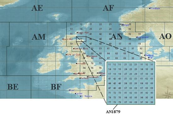
When assigning square numbers, not all numbers were used. They were also irregularly assigned, but generally the first matrix would contain squares numbered from 11 to 19, the second from 21 to 29, the third from 31 to 39 and so on. Even the large sectors were not divided equally for tactical reasons. For example, sector AN was tactically divided to cover the area from the North Sea to the east of Britain, while AM covered the west of Britain. Similarly, sector BF covered the entire coast of France. Sectors were often divided by zone of operations.
During the later part of the war, the Germans suspected that the Allies were deciphering their patrol reports. Although they were never certain, but as a precautionary measure Donitz transmitted patrol zones by using coded sectors. Instead of transmitting the actual patrol zone, he would use an offset, so that any zone that was transmitted over the waves would be an offset of a secret location. This secret location was changed at random intervals, and U-boat captains would calculate the new patrol zone based on the offset.